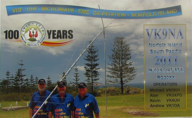
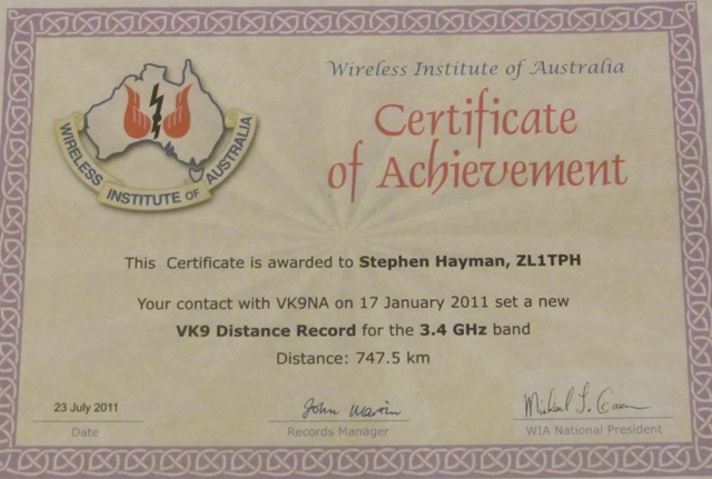
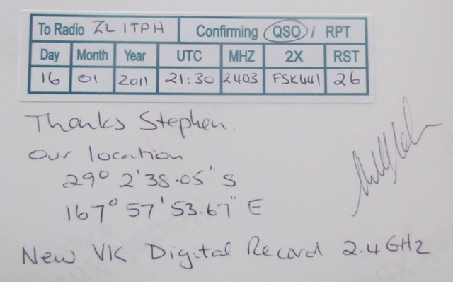
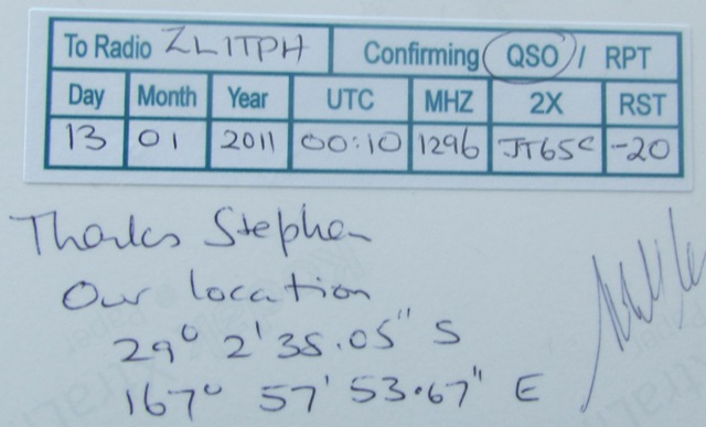
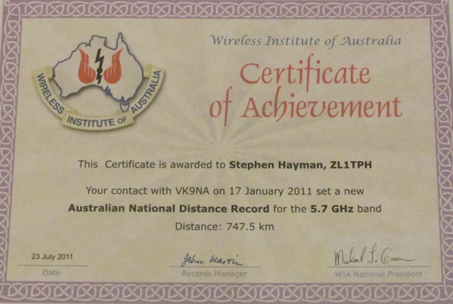
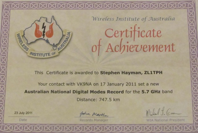
QSL Cards from the VK9NA team and certificates frrom the W.I.A
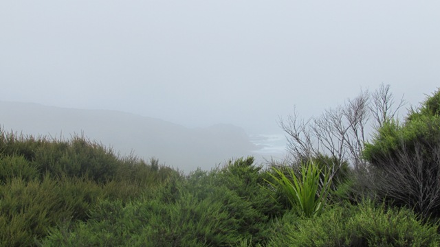
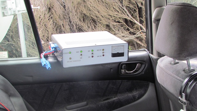
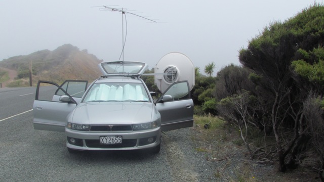
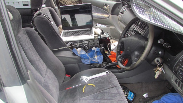
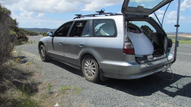
Above 3.4 GHz. To the right 150 Watts (below) 1296 PA. Front seat of the wagon and old TS700A 2 m radio to a 250 Watts SSPA. Note the mist at Cape Reinga, the same time band was wide open on microwave to VK9NA (753 km). 3 cm or 10368 MHz was attempted but no signals heard each way.
This analysis is from a non radio person. From a friend whom was 40 years at sea, all over the world and was Master or Captain - and these ships were large cargo freight vessels.
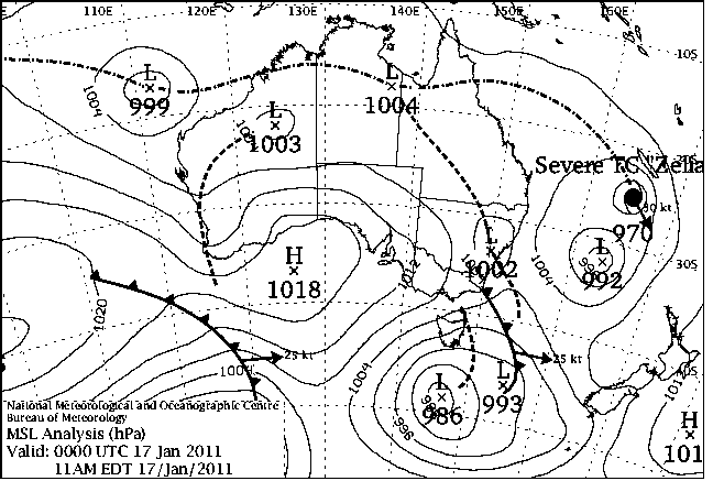
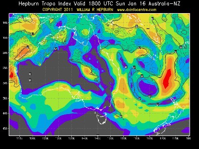
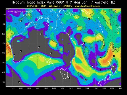
The very intense inversion layer (Red on the Hepburn chart) moving down between Norfolk Island and Cape Reinga coincides with the area between the two low pressure systems 970 hPa and 992 hPa.
This area will be unstable moist air sinking and spreading out causing a temperature inversion with high humidity in excess of 90 percent.
The larger intense area follows the Australian coast down to the low (993 hPa) south of Tasmania. Warm tropical air again, unstable and moisture laden.
Above 5.76 GHz dish feed
Analysis(Steve, ZL1TWR)
I suspect this one you mention, it’s tied up somewhat with the abnormal erratic weather around northern Queensland, which is similar to what we have had in the last few days, noticing these areas of warmth & moisture drift down from the tropics. Cyclones whirl around low pressures, causing the higher pressure warm air in the area to gradually fill in the low cyclone, thereby raising the temperature & of the cyclone this time.
I noted temperatures in the north of Queensland were in the 30-35c range as the cyclone came near the coast, which would cause this high temperature air mass to be sucked into the lower pressure & temperature area air mass over the sea, raising its temperature.
This would in turn would cause a moist warm air to form, after hitting a colder mass, & which would then rise above surrounding sea area, stabilising at a level where it meets colder air at higher altitude, which would bring more condensation, & hence moisture. As it dissipates due to filling in, portions drift away from the centre with variable temperature & moisture contents, which come up against other air masses, forming small areas of intense inversion layer or ducts for enhanced radio propagation.
W.I.A report;
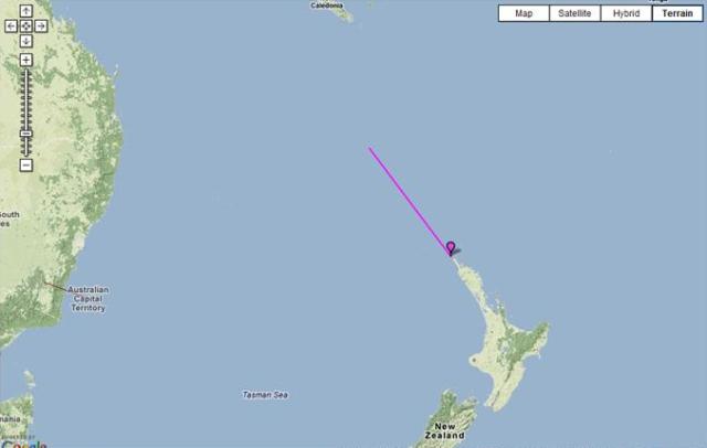
To support the VK9NA VHF and microwave DXpedition to Norfolk Island from January the 9th to the 19th 2011, we drove to the top of New Zealand and operated portable out of a vehicle for the same two week period. Two sites were chosen because of easy road access and panoramic elevated views into the ocean looking towards VK9NA. One portable QTH chosen was Ahipara on the west coast and commonly known in New Zealand as the Gum fields, a high 200 m plateau located at RF64NT and 838 km distance to Norfolk Island. The other portable site was at the top of New Zealand, called Cape Reinga at RF65IN and being closer at 748 km to Norfolk Island and at 175 m ASL.
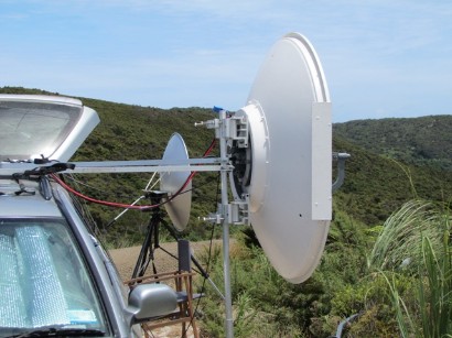
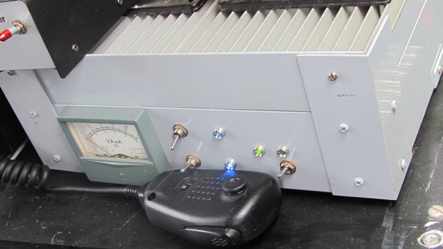
Our prime focus was the microwave bands from 23 cm to 3 cm with 144 MHz as liaison. Our station on VHF was 250 Watts to an 8 element horizontal Yagi on 2 m. With the microwave bands a 1.25 m diameter Andrew dish with 150 Watts on 23 cm, 100 Watts on 12 cm, 20 Watts on 9 cm, 100 Watts on 6 cm and 5 Watts only on the 3 cm amateur band. For a numbers of days I was assisted on site by both Simon ZL1SWW and Harry ZL1BK with many thanks on two separate occasions.
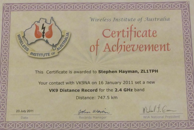
It became clearly evident over the first week and a half, with the many excursions to our two portable sites in the far north that VK9NA were easily worked or heard at either 838 km or 748 km distance with their fine 2 m station at around S2, but the conditions only provided marginal propagation on the 23 cm band. However a personal best distance was achieved with VK9NA on 1296 MHz SSB / Digi at 838 km from the Gum fields on the 13th January NZT. They were received at best -12 with the JT65C digital mode.
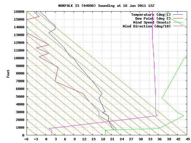
Watching the Hepburn charts as the days went by, we saw what could be an intense inversion layer appearing on Sunday the 16th of January UTC at around 1800 or thereafter, with red on the Hepburn indicative of “Very Intense Propagation” between Cape Reinga (RF65IN) up to Norfolk Island (RG30XW) at 748 km.
Tropical Cyclone Zelia was coming down from the tropics in a Southerly direction towards both Norfolk Island and New Zealand at this time. Cyclones that come down from the tropics actually diminish in general or become weaker. A high at the same time had moved across the top of New Zealand and was heading Westerly away past Cape Reinga. It was decided with prior emails to VK9NA that we attempt at 1900 UTC on the morning of the 16th January 2011 (8 am Monday 17th NZT)
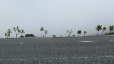
Driving north from my motel accommodation at 6:30 am in the morning from Kaitaia, it was raining and wet and dismal. Arriving at Cape Reinga 1.5 hours later at 8 am, it was surprisingly dry underfoot but in the clouds and mist and the humidy was extremely high with no visibility whatsoever. Initial contact on 2 m was not that strong at only S2 at 748 km distance.
We both decided to set up our respective 1.25 m dishes at each end, and then tested on 12 cm (2.4 GHz) with no success. A call was made for more accurate dish alignment at my end, because with no visibility, I had lost my accurate ridge line bearing at 200 metre distance away, which points to Norfolk Island. We dropped down to the 23 cm and I locked my dish on the VK9NA signal.
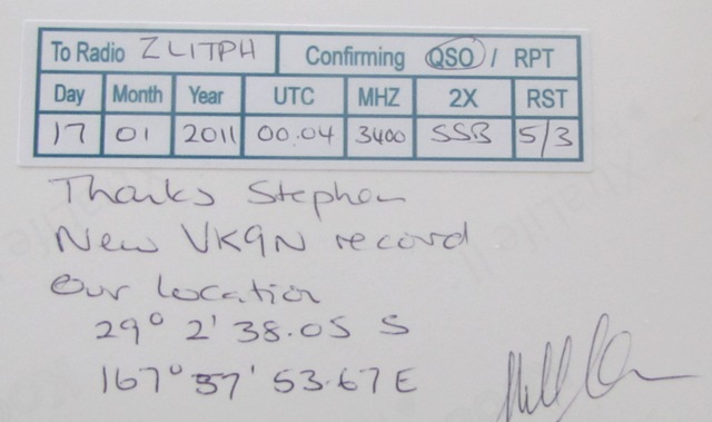
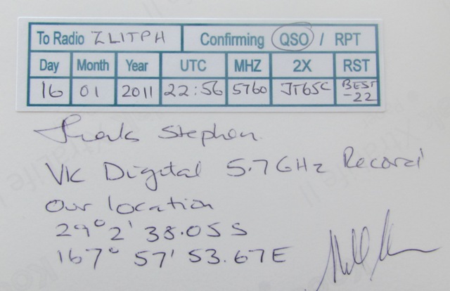
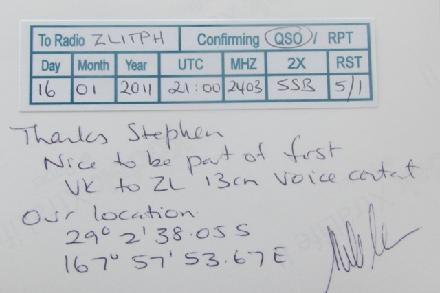
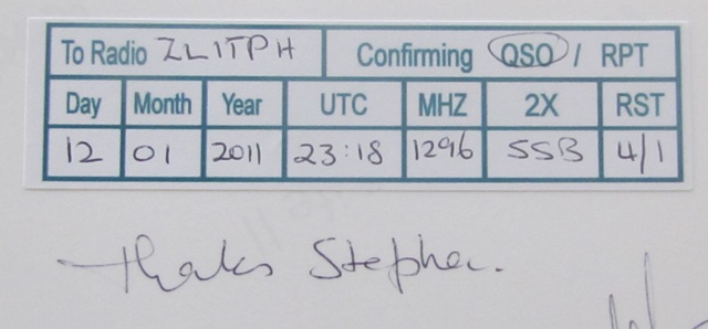
With tests again on 12 cm, their beeper identification was easily heard, resulting in a weak SSB contact on 2.4 GHz with headphones on at 10 am NZT. Digital JT65c was then attempted, but the frequency instability at my station resulted in no decode. We moved to the digital mode FSK441 as an attempt to complete a digital QSO on 12 cm which was achieved. Signals at this point were becoming stronger on my receive and VK9NA asked for an additional piece of unknown information sent to me on 2.4 GHz, received was “RECORD 73 RECORD 73 RECORD 73 RECORD” on my PC.
At around 10 am ZL time or 2100 UTC our liaison frequency on the 2 m band surprisingly went up to S9 plus +. At one point, operator Alan VK3XPD reduced power from 400 Watts to 35 Watts on 2 m and was still S9 with no QSB. It turned out we now had a three to four hour intense temperature inversion.
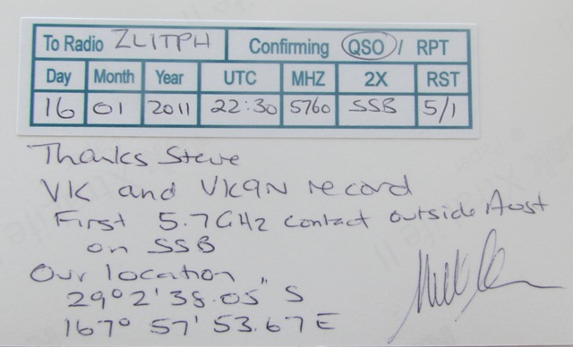
We now moved up to the 5.76 GHz band. The initial received signal from VK9NA was not strong but VK9NA was easily heard at my station at around 11:30 are NZT. VK9NA could not hear my return transmission on 6 cm. Alan VK3XPD made an excellent call and asked, “If you can hear us OK, how about going outside and check your dish alignment. I swung the dish only a few degrees to the north and VK9NA were now 57 and extremely loud on 5.76 GHz. We completed on SSB to VK9NA, to operator Kevin VK4UH.
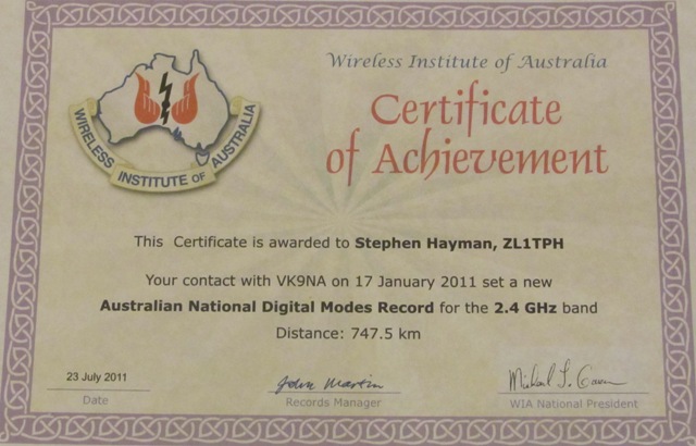
With our 5.76 GHz stations, both were locked either to a GPS 10 MHz reference or a 10 MHz TCXO for frequency stability, we now tested JT65C. Best decode was -5 with callsign exchange along with an additional piece of information sent as an extra requirement from VK9NA, with the words “RECORD STEVE” received at -14.
Once that was complete we attempted a contact on 10 GHz or the 3 cm band. No signals were heard each way, but at the time the TWTA from VK9NA was not fully operational.
A call was then made to move back down the bands and test on 3.4 GHz or the 9 cm band at 1 pm NZT. The VK9NA signal was easily heard on this band also, resulting with a fine SSB contact to station operator, Kevin VK4UH once again. Signal reports from Norfolk Island on this band ranged from 51 to 59 at around 1 pm NZT on SSB. We attempted JT65C on 9 cm but it was soon evident, that my 9 cm transverter was not stable enough for this transmission mode. The line coming down the screen was clear but all over the place. We then changed to FSK441, but shortly afterwards the band started to close. VK9NA was now gone on 9 cm at around 1:30 pm NZT, both ways to our surprise, and so no digital contact resulted.
We checked the 2 m band at around 2:00 pm NZT. The 2m band was down to S2 and the intense opening looked to be over. We tested 10 GHz again with VK9NA now having fixed there 100 Watt TWTA power amplifier, but nothing was heard on 10 GHz from VK9NA or from my station to VK9NA. The intense opening to VK9NA, we believe, only lasted for around three hours that day, from 10 am to around 2 pm NZT on the 17th of January 2011. We both packed up our stations and I left Cape Reinga at 3 pm NZT for another 1.5 hour drive back to the Kaitaia motel.
The high anticyclone, moving westerly away, across the upper north island of New Zealand, along with tropical cyclone Zelia moving down towards ZL and Norfolk Island we believe created a small and narrow intense inversion layer or duct. The inversion layer itself, which was clearly evident on the Hepburn charts, along with excellent propagation, coincided with an area between two low pressure systems of 970 hPa and 991 hPa. This area will be unstable moist air sinking and spreading out with very high humidy in excess of 90 percent.
Mentioned on the radio, one of the VK9NA operators said, “That the mist was moving in on their operating site at Norfolk Island. They VK9NA were operating at only 50 m above sea level and the Cape Reinga beam heading towards ZL was through Norfolk pines located nearby.
Monday the 17th Jan 2011, from the VK9NA website was reported, “The sked with ZL1TPH confirmed that conditions were good enough to try a contact on 2.4 GHz. Later contact was made with ZL1TPH on 2.4, 3.4 and 5.7 GHz and we think there were some records broken by those contacts. Later in the day the weather forecast was that a cyclone would pass over the island overnight. In preparation for that all antennas were dismantled. The storm "missed us by a whisker" and plans are to reassemble the 2m / 70cm + station on Mt Pitt if possible and to raise the EME antenna again in time for some EME activity later in the afternoon and evening”.
The station operators, with the VK9NA DXpedition to Norfolk Island were, “Alan VK3XPD, Kevin VK4UH, Michael VK3KH and Andrew VK1DA. New Zealand amateur radio operators would like to thank the VK9NA team for activating Norfolk Island once again in January 2011.
73 Stephen, ZL1TPH